
Use the Nueces County Street Directory for an Address Trail
An address search is strongest when each source answers a separate question. NCAD can identify the taxable parcel and its listed owner, the map places that parcel among adjoining lots, and the County Clerk index can connect the legal description to a recorded transfer. The voter lookup is a person-keyed status tool, not a street browse. Historic directories may identify an occupant or subscriber for a particular year, but they do not establish current residence or ownership.
- Enter the house number and simplified street name in NCAD, then record the situs address, owner spelling, property or geographic ID, legal description, subdivision, lot or block, and tax year shown.
- Open the same parcel in the NCAD GIS viewer. Compare its geometry, city-limit layer, ZIP layer, and nearby parcels before assuming a road belongs to one custodian.
- Search the current owner as grantee in the County Clerk GovOS portal and the historic Kofile index. Use the grantor from the deed as the next backward-search name.
- Use the Secretary of State voter tool only to check a known person through its DL-number, VUID, or first-and-last-name paths. Do not try to make it into a block roster.
- For older occupants, ask the Corpus Christi Public Library for a reverse or criss-cross directory volume and preserve the address, year, and source with each entry.
Search NCAD for a Nueces County Street Directory Result
The Nueces County Appraisal District property search has Owner, ARB Search, and Advanced tabs. A simple search uses Owner Name and Street Number. For a road search, Advanced Street Name specifically asks for no prefix, suffix, or unit number. Start broad, then use the parcel identifiers and legal description to separate similar results. The visible property search has no ZIP field, so ZIP work belongs in the GIS layer or USPS verification.
| NCAD control | Input type | Street-search use |
|---|---|---|
| Owner Name | Text | Optional; enter last name first, such as Smith John. |
| Street Number | Text | Optional simple-search field; use the number only. |
| Street Name | Text | Optional Advanced field; omit prefix, suffix, and unit number. |
| Property ID | Text | Optional account or property identifier when it is already known. |
| Geographic ID | Text | Optional parcel-geography identifier for cross-reference. |
| Subdivision | Autocomplete | Optional list selection that can narrow a repeated street name. |
| Property Type and Tax Year | Dropdowns | Optional dynamic filters for refining results. |
| DBA and Owner ID | Text | Optional alternate owner-related fields when the record supplies them. |
| Neighborhood and Abstract | Autocomplete | Optional location filters; choices are dynamic in the portal. |
| Protest and hearing fields | Dropdown or date | Optional appeal-related filters, not proof of occupancy. |
Read the result as a taxable-parcel record. Its owner, account, physical location, mailing address, legal description, exemptions, values, and map link are useful clues, while NCAD says that legal descriptions and acreage should still be verified. Its 2026 values are preliminary and subject to change.
Mailing and Situs Fields in the Nueces County Street Directory
Situs means the physical place of the parcel. The mailing address is where tax correspondence is sent. They can match, but an owner may use a post-office box, an out-of-county address, or an agent or representative address. Record both fields as displayed and attach a tax year or access date to your notes. A change in a mailing field may show where correspondence went, not who lived at the parcel on that date.
Address terms. A parcel is the taxable tract NCAD identifies; its situs address is the physical location. A plat maps lot, block, and subdivision layout. A criss-cross directory is a historical address-to-occupant reference volume.
A homestead exemption flag can be owner-occupancy evidence for tax purposes when it is present. Its absence does not prove that an owner did not occupy the place, because eligibility, timing, and ownership arrangements can differ. Keep that uncertainty with any street-directory note.
Map a Nueces County Street Directory Result in GIS
The NCAD GIS viewer carries a result from a street list into a parcel map. County material describes parcel, city-limit, street, subdivision, ZIP, zoning, floodplain, school, water, drainage, emergency-service district, neighborhood, and sales-related layers, along with orientation, scale, measurement, and identify tools. Click or identify a parcel, note the geographic or account ID, then compare the adjacent lots one at a time with their individual NCAD records.
The annual report describes a complete county map archive dating to 1982. A 2026 RFP also describes spatial queries, buffers, downloadable layers, and split or merge history, but those items may be evolving rather than confirmed controls in the live viewer. Verify the current click labels and any public buffer option before relying on them for a block study.
Nueces County Records Searchable by Street
No one Nueces County office keeps a complete household list by road. The records below are address-linked in different ways, so the useful result is a dated chain of parcel, map, legal document, and historical source rather than a single claim about everyone at a location. When an online index stops, the research path continues at the clerk counter, library, archive, or a request to the correct custodian.
| Address-linked source | Custodian | What the record can show | Access route |
|---|---|---|---|
| Appraisal parcel | NCAD | Tax-listed owner, situs, mailing address, legal description, value, exemptions, and identifiers | Free online property search; preliminary-value notice applies |
| GIS parcel map | NCAD GIS | Parcels, adjacency, city limits, ZIP, zoning, flood, and district context | Public map; live selection mechanics should be checked |
| Deed and index | County Clerk, GovOS, Kofile, and TSLAC | Grantor, grantee, transfer date, instrument placement, and legal description | Current portal, historic index, microfilm, counter, phone, or copy request |
| Plat or restriction | County Clerk | Lot, block, subdivision, easement, restriction, and street layout clues | Kofile Plats and clerk or microfilm access |
| Voter record | Texas SOS and county registrar | Lawful registration and polling context for a known person | Person-keyed lookup, controlled file request, phone, or in-person path |
| Permit | Corpus Christi Development Services or county Public Works | Application, review, inspection, and building-work clues | Dynamic Portal or a request for older city or county files |
| Historical directory | CCPL and TSLAC | Occupant or subscriber at an address and year | Reference room, archive, and library staff assistance |
Tax collection is separate from appraisal. The Tax Assessor/Collector administers county and entity collection, while NCAD appraises the parcel. A payment receipt supplies tax context, but it is not proof of title.
Move From a Nueces County Street Directory Parcel to a Deed
Use the parcel’s legal description, subdivision, lot or block, geographic ID, current owner, and address as separate County Clerk search variants. In the Nueces County Official Public Records search, Quick Search accepts a search term, date range, and index-only or OCR/full-text mode. Search the current owner as grantee to find an acquisition, identify the seller or grantor, and then search that person as an earlier grantee. Trusts, estates, corporations, and name order can require more than one party search.
The County Clerk’s current OPR search is shown below. It is a modern index route, not a promise that every historic image or series is available online.
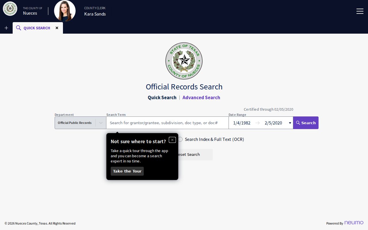
The search controls are most useful when a street name is paired with a legal description or party name. The page’s “Certified through 02/05/2020 Department” notice is not a clerk-confirmed complete online cutoff, so inspect returned dates and ask the County Clerk about a specific record gap.
The Nueces County Street Directory and Historic Kofile Books
The Kofile Quick Links historic index is the older-record complement to GovOS. It lists Deeds from 1847 through 1972 and a later Real Property run from 1973 through 1982, plus Plats from 1847 through 2018. Restrictions, lis pendens, mechanic and materialmen’s liens, and deeds of trust can add context to a parcel. The Deeds and Real Property labels are a real period change, not interchangeable terms.
This Kofile index screen provides the book, type, year, and party path for a historic record.
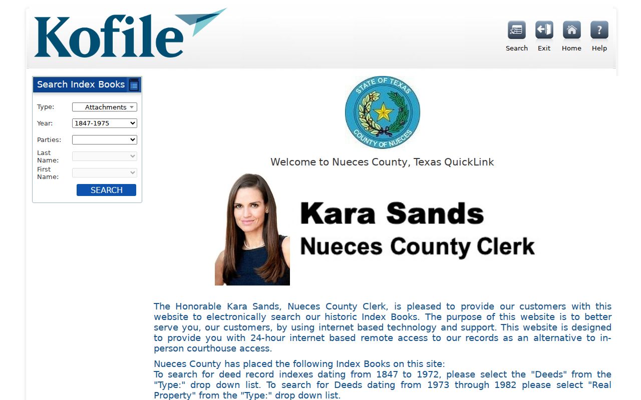
After an index entry yields a book, volume, page, or document placement, use that citation at the County Clerk counter or with the relevant image or copy channel. For early gaps, TSLAC lists Nueces deed records from 1847 through 1886 and a deed index through 1902 through its repository path.
Nueces County Street Directory Permit Clues
Permits add a building and inspection layer to a street search. Corpus Christi’s Dynamic Portal allows anonymous searches by address, permit number, or date range. A record can include application documents, review comments, paid-fee status, inspections, and permit cards. Inspection events may not appear until fees are paid. For a street outside the city, county floodplain permits go through Public Works, so confirm the parcel’s municipal status before treating city permit results as countywide.
Corpus Christi’s Dynamic Portal guidance illustrates the official permit-search route.
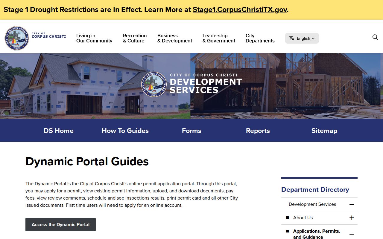
This source can establish a dated work or review clue, not a complete resident record. No verified public countywide code-enforcement index or historic permit archive was found, so request a defined address and date range from the city or county custodian under the Texas Public Information Act.
Rural and Municipal Addresses in Nueces County
Nueces County contains urban, coastal, rural, and island address systems. County Public Works assigns and maintains uniform rural addresses, updates PSAP information, and uses an Address Verification Form for a new rural house or changed residence. Its guidance asks that the number be at least three inches high and plainly visible. Corpus Christi, Port Aransas, Robstown, Bishop, Agua Dulce, Driscoll, and other incorporated places can require a municipal custodian instead.
A November 2023 county hearing changed Bernice Drive to Bernice Lane, a useful reminder to try historic road variants. No countywide renumbering or renaming list was located. When an old address fails, bridge it with plats, Commissioners Court or city records, historic directories, and Sanborn maps rather than assuming the recorded tract disappeared.
Old Occupants Along a Nueces County Street
Corpus Christi Public Library’s Local History Department holds city directories, yearbooks, obituaries, special collections, newspapers, and reference sources that can add the people layer missing from parcel records. Exact reverse-directory runs were not verified, so ask for reverse or criss-cross volumes instead of assuming that every year or road is covered. The published Corpus Christi directory list includes selected years from 1913–14 through 1993, with gaps including 1970.
An entry can identify an occupant or subscriber at a given address and year, but not title or a present household. For the collections and how to read a historical entry, use the Nueces County Directory Book; return to deeds and NCAD when the question is the parcel rather than the former listing.
Requesting Missing Nueces County Street Records
When the appraisal, portal, and library routes do not yield a needed existing record, direct a Texas Public Information Act request to the office that keeps it. Describe the address, date range, record type, and desired format. A request asks for an existing record, not a newly created analysis. County Clerk copies and certifications, NCAD information, historic material, city permits, and county floodplain files each have different custodians and access limits.
NCAD’s public-information request page is one official request channel for appraisal-district material.
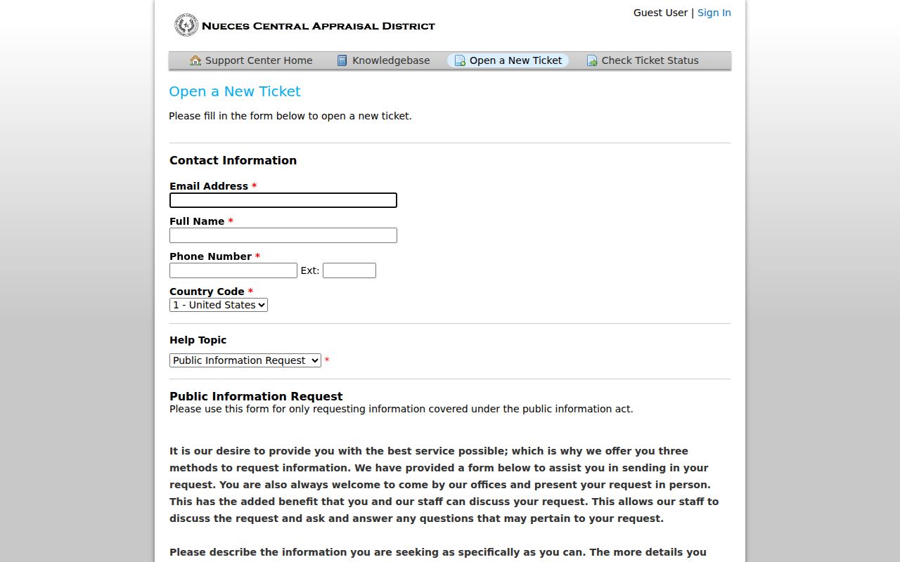
The form is a fallback for a defined public record, not a shortcut around confidential fields. If an office expects charges above $40, Texas guidance calls for a written estimate; inspect current requirements before submitting.
What a Nueces County Street Directory Cannot Show
A street result cannot prove every person at a parcel. NCAD identifies taxable ownership and correspondence fields, not a household census. The voter tool is keyed to a person and does not offer a public street browse; protected addresses can be suppressed, and ballot choices are not public. Utilities and motor-vehicle records are not public address layers, and the DPPA protects personal information from motor-vehicle records. A missing match is not proof that a person is absent.
Lawful use. Use Nueces County address records for personal, civic, property, or family-history research. Do not use the information to stalk, harass, intimidate, or harm any person, and do not republish protected data as a street list.